OPENDAP NAM
![]()
# Install required libraries
# !pip install -q xarray_subset_grid@git+https://github.com/asascience-open/xarray-subset-grid.git
# !pip install -q s3fs cftime xarray cf-xarray fsspec dask h5netcdf
import cf_xarray  # noqa
import datetime
import xarray as xr


current_date = datetime.datetime.now().strftime("%Y%m%d")

ds = xr.open_dataset(
    f"https://nomads.ncep.noaa.gov/dods/nam/nam{current_date}/nam1hr_00z", chunks={}
)
ds
/Users/matthew.iannucci/Developer/xarray-subset-grid/venv/lib/python3.10/site-packages/xarray/coding/times.py:170: SerializationWarning: Ambiguous reference date string: 1-1-1 00:00:0.0. The first value is assumed to be the year hence will be padded with zeros to remove the ambiguity (the padded reference date string is: 0001-1-1 00:00:0.0). To remove this message, remove the ambiguity by padding your reference date strings with zeros.
  warnings.warn(warning_msg, SerializationWarning)
<xarray.Dataset> Size: 31GB
Dimensions:         (time: 37, lev: 42, lat: 443, lon: 913)
Coordinates:
  * time            (time) datetime64[ns] 296B 2024-07-24 ... 2024-07-25T12:0...
  * lev             (lev) float64 336B 1e+03 975.0 950.0 925.0 ... 20.0 10.0 5.0
  * lat             (lat) float64 4kB 12.22 12.33 12.44 ... 60.98 61.09 61.21
  * lon             (lon) float64 7kB -152.9 -152.8 -152.7 ... -49.59 -49.47
Data variables: (12/141)
    absvprs         (time, lev, lat, lon) float32 3GB dask.array<chunksize=(37, 42, 443, 913), meta=np.ndarray>
    no4lftx180_0mb  (time, lat, lon) float32 60MB dask.array<chunksize=(37, 443, 913), meta=np.ndarray>
    acpcpsfc        (time, lat, lon) float32 60MB dask.array<chunksize=(37, 443, 913), meta=np.ndarray>
    albdosfc        (time, lat, lon) float32 60MB dask.array<chunksize=(37, 443, 913), meta=np.ndarray>
    apcpsfc         (time, lat, lon) float32 60MB dask.array<chunksize=(37, 443, 913), meta=np.ndarray>
    bmixlhy1        (time, lat, lon) float32 60MB dask.array<chunksize=(37, 443, 913), meta=np.ndarray>
    ...              ...
    vucsh0_6000m    (time, lat, lon) float32 60MB dask.array<chunksize=(37, 443, 913), meta=np.ndarray>
    vvcsh0_6000m    (time, lat, lon) float32 60MB dask.array<chunksize=(37, 443, 913), meta=np.ndarray>
    vvelprs         (time, lev, lat, lon) float32 3GB dask.array<chunksize=(37, 42, 443, 913), meta=np.ndarray>
    weasdaccsfc     (time, lat, lon) float32 60MB dask.array<chunksize=(37, 443, 913), meta=np.ndarray>
    weasdsfc        (time, lat, lon) float32 60MB dask.array<chunksize=(37, 443, 913), meta=np.ndarray>
    wiltsfc         (time, lat, lon) float32 60MB dask.array<chunksize=(37, 443, 913), meta=np.ndarray>
Attributes:
    title:        NAM hourly fcst staring from 00Z24jul2024, download Jul 24 ...
    Conventions:  COARDS\nGrADS
    dataType:     Grid
    history:      Wed Jul 24 02:49:03 UTC 2024 : imported by GrADS Data Serve...
xarray.Dataset
- time: 37
- lev: 42
- lat: 443
- lon: 913
- time(time)datetime64[ns]2024-07-24 ... 2024-07-25T12:00:00
- grads_dim :
- t
- grads_mapping :
- linear
- grads_size :
- 37
- grads_min :
- 00z24jul2024
- grads_step :
- 1hr
- long_name :
- time
- minimum :
- 00z24jul2024
- maximum :
- 12z25jul2024
- resolution :
- 0.041666668
array(['2024-07-24T00:00:00.000000000', '2024-07-24T01:00:00.000000000', '2024-07-24T02:00:00.000000000', '2024-07-24T03:00:00.000000000', '2024-07-24T04:00:00.000000000', '2024-07-24T05:00:00.000000000', '2024-07-24T06:00:00.000000000', '2024-07-24T07:00:00.000000000', '2024-07-24T08:00:00.000000000', '2024-07-24T09:00:00.000000000', '2024-07-24T10:00:00.000000000', '2024-07-24T11:00:00.000000000', '2024-07-24T12:00:00.000000000', '2024-07-24T13:00:00.000000000', '2024-07-24T14:00:00.000000000', '2024-07-24T15:00:00.000000000', '2024-07-24T16:00:00.000000000', '2024-07-24T17:00:00.000000000', '2024-07-24T18:00:00.000000000', '2024-07-24T19:00:00.000000000', '2024-07-24T20:00:00.000000000', '2024-07-24T21:00:00.000000000', '2024-07-24T22:00:00.000000000', '2024-07-24T23:00:00.000000000', '2024-07-25T00:00:00.000000000', '2024-07-25T01:00:00.000000000', '2024-07-25T02:00:00.000000000', '2024-07-25T03:00:00.000000000', '2024-07-25T04:00:00.000000000', '2024-07-25T05:00:00.000000000', '2024-07-25T06:00:00.000000000', '2024-07-25T07:00:00.000000000', '2024-07-25T08:00:00.000000000', '2024-07-25T09:00:00.000000000', '2024-07-25T10:00:00.000000000', '2024-07-25T11:00:00.000000000', '2024-07-25T12:00:00.000000000'], dtype='datetime64[ns]') - lev(lev)float641e+03 975.0 950.0 ... 20.0 10.0 5.0
- grads_dim :
- z
- grads_mapping :
- levels
- units :
- millibar
- long_name :
- altitude
- minimum :
- 1000.0
- maximum :
- 5.0
- resolution :
- 24.268293
array([1000., 975., 950., 925., 900., 875., 850., 825., 800., 775., 750., 725., 700., 675., 650., 625., 600., 575., 550., 525., 500., 475., 450., 425., 400., 375., 350., 325., 300., 275., 250., 225., 200., 175., 150., 125., 100., 75., 50., 20., 10., 5.]) - lat(lat)float6412.22 12.33 12.44 ... 61.09 61.21
- grads_dim :
- y
- grads_mapping :
- linear
- grads_size :
- 443
- units :
- degrees_north
- long_name :
- latitude
- minimum :
- 12.219908
- maximum :
- 61.20556254545
- resolution :
- 0.110827275
array([12.219908, 12.330735, 12.441563, ..., 60.983908, 61.094735, 61.205563])
- lon(lon)float64-152.9 -152.8 ... -49.59 -49.47
- grads_dim :
- x
- grads_mapping :
- linear
- grads_size :
- 913
- units :
- degrees_east
- long_name :
- longitude
- minimum :
- -152.878623
- maximum :
- -49.47263081081
- resolution :
- 0.11338376
array([-152.878623, -152.765239, -152.651855, ...,  -49.699398,  -49.586015,
        -49.472631])
- absvprs(time, lev, lat, lon)float32dask.array<chunksize=(37, 42, 443, 913), meta=np.ndarray>
- long_name :
- ** (1000 850 700 500 250) absolute vorticity [1/s]
Array Chunk Bytes 2.34 GiB 2.34 GiB Shape (37, 42, 443, 913) (37, 42, 443, 913) Dask graph 1 chunks in 2 graph layers Data type float32 numpy.ndarray - no4lftx180_0mb(time, lat, lon)float32dask.array<chunksize=(37, 443, 913), meta=np.ndarray>
- long_name :
- ** 180-0 mb above ground best (4 layer) lifted index [k]
Array Chunk Bytes 57.09 MiB 57.09 MiB Shape (37, 443, 913) (37, 443, 913) Dask graph 1 chunks in 2 graph layers Data type float32 numpy.ndarray - acpcpsfc(time, lat, lon)float32dask.array<chunksize=(37, 443, 913), meta=np.ndarray>
- long_name :
- ** surface convective precipitation [kg/m^2]
Array Chunk Bytes 57.09 MiB 57.09 MiB Shape (37, 443, 913) (37, 443, 913) Dask graph 1 chunks in 2 graph layers Data type float32 numpy.ndarray - albdosfc(time, lat, lon)float32dask.array<chunksize=(37, 443, 913), meta=np.ndarray>
- long_name :
- ** surface albedo [%]
Array Chunk Bytes 57.09 MiB 57.09 MiB Shape (37, 443, 913) (37, 443, 913) Dask graph 1 chunks in 2 graph layers Data type float32 numpy.ndarray - apcpsfc(time, lat, lon)float32dask.array<chunksize=(37, 443, 913), meta=np.ndarray>
- long_name :
- ** surface total precipitation [kg/m^2]
Array Chunk Bytes 57.09 MiB 57.09 MiB Shape (37, 443, 913) (37, 443, 913) Dask graph 1 chunks in 2 graph layers Data type float32 numpy.ndarray - bmixlhy1(time, lat, lon)float32dask.array<chunksize=(37, 443, 913), meta=np.ndarray>
- long_name :
- ** 1 hybrid level blackadars mixing length scale [m]
Array Chunk Bytes 57.09 MiB 57.09 MiB Shape (37, 443, 913) (37, 443, 913) Dask graph 1 chunks in 2 graph layers Data type float32 numpy.ndarray - capesfc(time, lat, lon)float32dask.array<chunksize=(37, 443, 913), meta=np.ndarray>
- long_name :
- ** surface convective available potential energy [j/kg]
Array Chunk Bytes 57.09 MiB 57.09 MiB Shape (37, 443, 913) (37, 443, 913) Dask graph 1 chunks in 2 graph layers Data type float32 numpy.ndarray - cape180_0mb(time, lat, lon)float32dask.array<chunksize=(37, 443, 913), meta=np.ndarray>
- long_name :
- ** 180-0 mb above ground convective available potential energy [j/kg]
Array Chunk Bytes 57.09 MiB 57.09 MiB Shape (37, 443, 913) (37, 443, 913) Dask graph 1 chunks in 2 graph layers Data type float32 numpy.ndarray - cdsfc(time, lat, lon)float32dask.array<chunksize=(37, 443, 913), meta=np.ndarray>
- long_name :
- ** surface drag coefficient [non-dim]
Array Chunk Bytes 57.09 MiB 57.09 MiB Shape (37, 443, 913) (37, 443, 913) Dask graph 1 chunks in 2 graph layers Data type float32 numpy.ndarray - cfrzrsfc(time, lat, lon)float32dask.array<chunksize=(37, 443, 913), meta=np.ndarray>
- long_name :
- ** surface categorical freezing rain [-]
Array Chunk Bytes 57.09 MiB 57.09 MiB Shape (37, 443, 913) (37, 443, 913) Dask graph 1 chunks in 2 graph layers Data type float32 numpy.ndarray - cicepsfc(time, lat, lon)float32dask.array<chunksize=(37, 443, 913), meta=np.ndarray>
- long_name :
- ** surface categorical ice pellets [-]
Array Chunk Bytes 57.09 MiB 57.09 MiB Shape (37, 443, 913) (37, 443, 913) Dask graph 1 chunks in 2 graph layers Data type float32 numpy.ndarray - cinsfc(time, lat, lon)float32dask.array<chunksize=(37, 443, 913), meta=np.ndarray>
- long_name :
- ** surface convective inhibition [j/kg]
Array Chunk Bytes 57.09 MiB 57.09 MiB Shape (37, 443, 913) (37, 443, 913) Dask graph 1 chunks in 2 graph layers Data type float32 numpy.ndarray - cin180_0mb(time, lat, lon)float32dask.array<chunksize=(37, 443, 913), meta=np.ndarray>
- long_name :
- ** 180-0 mb above ground convective inhibition [j/kg]
Array Chunk Bytes 57.09 MiB 57.09 MiB Shape (37, 443, 913) (37, 443, 913) Dask graph 1 chunks in 2 graph layers Data type float32 numpy.ndarray - cnwatsfc(time, lat, lon)float32dask.array<chunksize=(37, 443, 913), meta=np.ndarray>
- long_name :
- ** surface plant canopy surface water [kg/m^2]
Array Chunk Bytes 57.09 MiB 57.09 MiB Shape (37, 443, 913) (37, 443, 913) Dask graph 1 chunks in 2 graph layers Data type float32 numpy.ndarray - crainsfc(time, lat, lon)float32dask.array<chunksize=(37, 443, 913), meta=np.ndarray>
- long_name :
- ** surface categorical rain [-]
Array Chunk Bytes 57.09 MiB 57.09 MiB Shape (37, 443, 913) (37, 443, 913) Dask graph 1 chunks in 2 graph layers Data type float32 numpy.ndarray - csnowsfc(time, lat, lon)float32dask.array<chunksize=(37, 443, 913), meta=np.ndarray>
- long_name :
- ** surface categorical snow [-]
Array Chunk Bytes 57.09 MiB 57.09 MiB Shape (37, 443, 913) (37, 443, 913) Dask graph 1 chunks in 2 graph layers Data type float32 numpy.ndarray - dlwrfsfc(time, lat, lon)float32dask.array<chunksize=(37, 443, 913), meta=np.ndarray>
- long_name :
- ** surface downward long-wave rad. flux [w/m^2]
Array Chunk Bytes 57.09 MiB 57.09 MiB Shape (37, 443, 913) (37, 443, 913) Dask graph 1 chunks in 2 graph layers Data type float32 numpy.ndarray - dpt2m(time, lat, lon)float32dask.array<chunksize=(37, 443, 913), meta=np.ndarray>
- long_name :
- ** 2 m above ground dew point temperature [k]
Array Chunk Bytes 57.09 MiB 57.09 MiB Shape (37, 443, 913) (37, 443, 913) Dask graph 1 chunks in 2 graph layers Data type float32 numpy.ndarray - dswrfsfc(time, lat, lon)float32dask.array<chunksize=(37, 443, 913), meta=np.ndarray>
- long_name :
- ** surface downward short-wave radiation flux [w/m^2]
Array Chunk Bytes 57.09 MiB 57.09 MiB Shape (37, 443, 913) (37, 443, 913) Dask graph 1 chunks in 2 graph layers Data type float32 numpy.ndarray - dzdtprs(time, lev, lat, lon)float32dask.array<chunksize=(37, 42, 443, 913), meta=np.ndarray>
- long_name :
- ** (1000 975 950 925 900.. 75 50 20 10 5) vertical velocity (geometric) [m/s]
Array Chunk Bytes 2.34 GiB 2.34 GiB Shape (37, 42, 443, 913) (37, 42, 443, 913) Dask graph 1 chunks in 2 graph layers Data type float32 numpy.ndarray - fricvsfc(time, lat, lon)float32dask.array<chunksize=(37, 443, 913), meta=np.ndarray>
- long_name :
- ** surface frictional velocity [m/s]
Array Chunk Bytes 57.09 MiB 57.09 MiB Shape (37, 443, 913) (37, 443, 913) Dask graph 1 chunks in 2 graph layers Data type float32 numpy.ndarray - gustsfc(time, lat, lon)float32dask.array<chunksize=(37, 443, 913), meta=np.ndarray>
- long_name :
- ** surface wind speed (gust) [m/s]
Array Chunk Bytes 57.09 MiB 57.09 MiB Shape (37, 443, 913) (37, 443, 913) Dask graph 1 chunks in 2 graph layers Data type float32 numpy.ndarray - hgtsfc(time, lat, lon)float32dask.array<chunksize=(37, 443, 913), meta=np.ndarray>
- long_name :
- ** surface geopotential height [gpm]
Array Chunk Bytes 57.09 MiB 57.09 MiB Shape (37, 443, 913) (37, 443, 913) Dask graph 1 chunks in 2 graph layers Data type float32 numpy.ndarray - hgtprs(time, lev, lat, lon)float32dask.array<chunksize=(37, 42, 443, 913), meta=np.ndarray>
- long_name :
- ** (1000 975 950 925 900.. 150 125 100 75 50) geopotential height [gpm]
Array Chunk Bytes 2.34 GiB 2.34 GiB Shape (37, 42, 443, 913) (37, 42, 443, 913) Dask graph 1 chunks in 2 graph layers Data type float32 numpy.ndarray - hgtclb(time, lat, lon)float32dask.array<chunksize=(37, 443, 913), meta=np.ndarray>
- long_name :
- ** cloud base geopotential height [gpm]
Array Chunk Bytes 57.09 MiB 57.09 MiB Shape (37, 443, 913) (37, 443, 913) Dask graph 1 chunks in 2 graph layers Data type float32 numpy.ndarray - hgtpbl(time, lat, lon)float32dask.array<chunksize=(37, 443, 913), meta=np.ndarray>
- long_name :
- ** planetary boundary layer geopotential height [gpm]
Array Chunk Bytes 57.09 MiB 57.09 MiB Shape (37, 443, 913) (37, 443, 913) Dask graph 1 chunks in 2 graph layers Data type float32 numpy.ndarray - hgtlwb0(time, lat, lon)float32dask.array<chunksize=(37, 443, 913), meta=np.ndarray>
- long_name :
- ** lowest level of the wet bulb zero geopotential height [gpm]
Array Chunk Bytes 57.09 MiB 57.09 MiB Shape (37, 443, 913) (37, 443, 913) Dask graph 1 chunks in 2 graph layers Data type float32 numpy.ndarray - hgt0c(time, lat, lon)float32dask.array<chunksize=(37, 443, 913), meta=np.ndarray>
- long_name :
- ** 0c isotherm geopotential height [gpm]
Array Chunk Bytes 57.09 MiB 57.09 MiB Shape (37, 443, 913) (37, 443, 913) Dask graph 1 chunks in 2 graph layers Data type float32 numpy.ndarray - hindexsfc(time, lat, lon)float32dask.array<chunksize=(37, 443, 913), meta=np.ndarray>
- long_name :
- ** surface haines index [numeric]
Array Chunk Bytes 57.09 MiB 57.09 MiB Shape (37, 443, 913) (37, 443, 913) Dask graph 1 chunks in 2 graph layers Data type float32 numpy.ndarray - hlcy3000_0m(time, lat, lon)float32dask.array<chunksize=(37, 443, 913), meta=np.ndarray>
- long_name :
- ** 3000-0 m above ground storm relative helicity [m^2/s^2]
Array Chunk Bytes 57.09 MiB 57.09 MiB Shape (37, 443, 913) (37, 443, 913) Dask graph 1 chunks in 2 graph layers Data type float32 numpy.ndarray - hpblsfc(time, lat, lon)float32dask.array<chunksize=(37, 443, 913), meta=np.ndarray>
- long_name :
- ** surface planetary boundary layer height [m]
Array Chunk Bytes 57.09 MiB 57.09 MiB Shape (37, 443, 913) (37, 443, 913) Dask graph 1 chunks in 2 graph layers Data type float32 numpy.ndarray - icecsfc(time, lat, lon)float32dask.array<chunksize=(37, 443, 913), meta=np.ndarray>
- long_name :
- ** surface ice cover [proportion]
Array Chunk Bytes 57.09 MiB 57.09 MiB Shape (37, 443, 913) (37, 443, 913) Dask graph 1 chunks in 2 graph layers Data type float32 numpy.ndarray - landsfc(time, lat, lon)float32dask.array<chunksize=(37, 443, 913), meta=np.ndarray>
- long_name :
- ** surface land cover (0=sea, 1=land) [proportion]
Array Chunk Bytes 57.09 MiB 57.09 MiB Shape (37, 443, 913) (37, 443, 913) Dask graph 1 chunks in 2 graph layers Data type float32 numpy.ndarray - lftxl100_100(time, lat, lon)float32dask.array<chunksize=(37, 443, 913), meta=np.ndarray>
- long_name :
- ** 500-1000 mb surface lifted index [k]
Array Chunk Bytes 57.09 MiB 57.09 MiB Shape (37, 443, 913) (37, 443, 913) Dask graph 1 chunks in 2 graph layers Data type float32 numpy.ndarray - lhtflsfc(time, lat, lon)float32dask.array<chunksize=(37, 443, 913), meta=np.ndarray>
- long_name :
- ** surface latent heat net flux [w/m^2]
Array Chunk Bytes 57.09 MiB 57.09 MiB Shape (37, 443, 913) (37, 443, 913) Dask graph 1 chunks in 2 graph layers Data type float32 numpy.ndarray - ltngsfc(time, lat, lon)float32dask.array<chunksize=(37, 443, 913), meta=np.ndarray>
- long_name :
- ** surface lightning [non-dim]
Array Chunk Bytes 57.09 MiB 57.09 MiB Shape (37, 443, 913) (37, 443, 913) Dask graph 1 chunks in 2 graph layers Data type float32 numpy.ndarray - maxrh2m(time, lat, lon)float32dask.array<chunksize=(37, 443, 913), meta=np.ndarray>
- long_name :
- ** 2 m above ground maximum relative humidity [%]
Array Chunk Bytes 57.09 MiB 57.09 MiB Shape (37, 443, 913) (37, 443, 913) Dask graph 1 chunks in 2 graph layers Data type float32 numpy.ndarray - maxuw10m(time, lat, lon)float32dask.array<chunksize=(37, 443, 913), meta=np.ndarray>
- long_name :
- ** 10 m above ground u component of hourly maximum 10m wind speed [m/s]
Array Chunk Bytes 57.09 MiB 57.09 MiB Shape (37, 443, 913) (37, 443, 913) Dask graph 1 chunks in 2 graph layers Data type float32 numpy.ndarray - maxvw10m(time, lat, lon)float32dask.array<chunksize=(37, 443, 913), meta=np.ndarray>
- long_name :
- ** 10 m above ground v component of hourly maximum 10m wind speed [m/s]
Array Chunk Bytes 57.09 MiB 57.09 MiB Shape (37, 443, 913) (37, 443, 913) Dask graph 1 chunks in 2 graph layers Data type float32 numpy.ndarray - minrh2m(time, lat, lon)float32dask.array<chunksize=(37, 443, 913), meta=np.ndarray>
- long_name :
- ** 2 m above ground minimum relative humidity [%]
Array Chunk Bytes 57.09 MiB 57.09 MiB Shape (37, 443, 913) (37, 443, 913) Dask graph 1 chunks in 2 graph layers Data type float32 numpy.ndarray - msletmsl(time, lat, lon)float32dask.array<chunksize=(37, 443, 913), meta=np.ndarray>
- long_name :
- ** mean sea level mslp (eta model reduction) [pa]
Array Chunk Bytes 57.09 MiB 57.09 MiB Shape (37, 443, 913) (37, 443, 913) Dask graph 1 chunks in 2 graph layers Data type float32 numpy.ndarray - mstav0_100cm(time, lat, lon)float32dask.array<chunksize=(37, 443, 913), meta=np.ndarray>
- long_name :
- ** 0-1 m below ground moisture availability [%]
Array Chunk Bytes 57.09 MiB 57.09 MiB Shape (37, 443, 913) (37, 443, 913) Dask graph 1 chunks in 2 graph layers Data type float32 numpy.ndarray - pli30_0mb(time, lat, lon)float32dask.array<chunksize=(37, 443, 913), meta=np.ndarray>
- long_name :
- ** 30-0 mb above ground parcel lifted index (to 500 hpa) [k]
Array Chunk Bytes 57.09 MiB 57.09 MiB Shape (37, 443, 913) (37, 443, 913) Dask graph 1 chunks in 2 graph layers Data type float32 numpy.ndarray - porossfc(time, lat, lon)float32dask.array<chunksize=(37, 443, 913), meta=np.ndarray>
- long_name :
- ** surface soil porosity [proportion]
Array Chunk Bytes 57.09 MiB 57.09 MiB Shape (37, 443, 913) (37, 443, 913) Dask graph 1 chunks in 2 graph layers Data type float32 numpy.ndarray - pressfc(time, lat, lon)float32dask.array<chunksize=(37, 443, 913), meta=np.ndarray>
- long_name :
- ** surface pressure [pa]
Array Chunk Bytes 57.09 MiB 57.09 MiB Shape (37, 443, 913) (37, 443, 913) Dask graph 1 chunks in 2 graph layers Data type float32 numpy.ndarray - pres80m(time, lat, lon)float32dask.array<chunksize=(37, 443, 913), meta=np.ndarray>
- long_name :
- ** 80 m above ground pressure [pa]
Array Chunk Bytes 57.09 MiB 57.09 MiB Shape (37, 443, 913) (37, 443, 913) Dask graph 1 chunks in 2 graph layers Data type float32 numpy.ndarray - presmwl(time, lat, lon)float32dask.array<chunksize=(37, 443, 913), meta=np.ndarray>
- long_name :
- ** max wind pressure [pa]
Array Chunk Bytes 57.09 MiB 57.09 MiB Shape (37, 443, 913) (37, 443, 913) Dask graph 1 chunks in 2 graph layers Data type float32 numpy.ndarray - prestrop(time, lat, lon)float32dask.array<chunksize=(37, 443, 913), meta=np.ndarray>
- long_name :
- ** tropopause pressure [pa]
Array Chunk Bytes 57.09 MiB 57.09 MiB Shape (37, 443, 913) (37, 443, 913) Dask graph 1 chunks in 2 graph layers Data type float32 numpy.ndarray - prmslmsl(time, lat, lon)float32dask.array<chunksize=(37, 443, 913), meta=np.ndarray>
- long_name :
- ** mean sea level pressure reduced to msl [pa]
Array Chunk Bytes 57.09 MiB 57.09 MiB Shape (37, 443, 913) (37, 443, 913) Dask graph 1 chunks in 2 graph layers Data type float32 numpy.ndarray - pwatclm(time, lat, lon)float32dask.array<chunksize=(37, 443, 913), meta=np.ndarray>
- long_name :
- ** entire atmosphere (considered as a single layer) precipitable water [kg/m^2]
Array Chunk Bytes 57.09 MiB 57.09 MiB Shape (37, 443, 913) (37, 443, 913) Dask graph 1 chunks in 2 graph layers Data type float32 numpy.ndarray - refcclm(time, lat, lon)float32dask.array<chunksize=(37, 443, 913), meta=np.ndarray>
- long_name :
- ** entire atmosphere (considered as a single layer) composite reflectivity [db]
Array Chunk Bytes 57.09 MiB 57.09 MiB Shape (37, 443, 913) (37, 443, 913) Dask graph 1 chunks in 2 graph layers Data type float32 numpy.ndarray - refd4000m(time, lat, lon)float32dask.array<chunksize=(37, 443, 913), meta=np.ndarray>
- long_name :
- ** 4000 m above ground reflectivity [db]
Array Chunk Bytes 57.09 MiB 57.09 MiB Shape (37, 443, 913) (37, 443, 913) Dask graph 1 chunks in 2 graph layers Data type float32 numpy.ndarray - refd1000m(time, lat, lon)float32dask.array<chunksize=(37, 443, 913), meta=np.ndarray>
- long_name :
- ** 1000 m above ground reflectivity [db]
Array Chunk Bytes 57.09 MiB 57.09 MiB Shape (37, 443, 913) (37, 443, 913) Dask graph 1 chunks in 2 graph layers Data type float32 numpy.ndarray - refdhy1(time, lat, lon)float32dask.array<chunksize=(37, 443, 913), meta=np.ndarray>
- long_name :
- ** 1 hybrid level reflectivity [db]
Array Chunk Bytes 57.09 MiB 57.09 MiB Shape (37, 443, 913) (37, 443, 913) Dask graph 1 chunks in 2 graph layers Data type float32 numpy.ndarray - retopclm(time, lat, lon)float32dask.array<chunksize=(37, 443, 913), meta=np.ndarray>
- long_name :
- ** entire atmosphere (considered as a single layer) echo top [m]
Array Chunk Bytes 57.09 MiB 57.09 MiB Shape (37, 443, 913) (37, 443, 913) Dask graph 1 chunks in 2 graph layers Data type float32 numpy.ndarray - rhprs(time, lev, lat, lon)float32dask.array<chunksize=(37, 42, 443, 913), meta=np.ndarray>
- long_name :
- ** (1000 975 950 925 900.. 150 125 100 75 50) relative humidity [%]
Array Chunk Bytes 2.34 GiB 2.34 GiB Shape (37, 42, 443, 913) (37, 42, 443, 913) Dask graph 1 chunks in 2 graph layers Data type float32 numpy.ndarray - rh2m(time, lat, lon)float32dask.array<chunksize=(37, 443, 913), meta=np.ndarray>
- long_name :
- ** 2 m above ground relative humidity [%]
Array Chunk Bytes 57.09 MiB 57.09 MiB Shape (37, 443, 913) (37, 443, 913) Dask graph 1 chunks in 2 graph layers Data type float32 numpy.ndarray - rhsg330_1000(time, lat, lon)float32dask.array<chunksize=(37, 443, 913), meta=np.ndarray>
- long_name :
- ** 0.33-1 sigma layer relative humidity [%]
Array Chunk Bytes 57.09 MiB 57.09 MiB Shape (37, 443, 913) (37, 443, 913) Dask graph 1 chunks in 2 graph layers Data type float32 numpy.ndarray - rh30_0mb(time, lat, lon)float32dask.array<chunksize=(37, 443, 913), meta=np.ndarray>
- long_name :
- ** 30-0 mb above ground relative humidity [%]
Array Chunk Bytes 57.09 MiB 57.09 MiB Shape (37, 443, 913) (37, 443, 913) Dask graph 1 chunks in 2 graph layers Data type float32 numpy.ndarray - rh60_30mb(time, lat, lon)float32dask.array<chunksize=(37, 443, 913), meta=np.ndarray>
- long_name :
- ** 60-30 mb above ground relative humidity [%]
Array Chunk Bytes 57.09 MiB 57.09 MiB Shape (37, 443, 913) (37, 443, 913) Dask graph 1 chunks in 2 graph layers Data type float32 numpy.ndarray - rh90_60mb(time, lat, lon)float32dask.array<chunksize=(37, 443, 913), meta=np.ndarray>
- long_name :
- ** 90-60 mb above ground relative humidity [%]
Array Chunk Bytes 57.09 MiB 57.09 MiB Shape (37, 443, 913) (37, 443, 913) Dask graph 1 chunks in 2 graph layers Data type float32 numpy.ndarray - rh120_90mb(time, lat, lon)float32dask.array<chunksize=(37, 443, 913), meta=np.ndarray>
- long_name :
- ** 120-90 mb above ground relative humidity [%]
Array Chunk Bytes 57.09 MiB 57.09 MiB Shape (37, 443, 913) (37, 443, 913) Dask graph 1 chunks in 2 graph layers Data type float32 numpy.ndarray - rh150_120mb(time, lat, lon)float32dask.array<chunksize=(37, 443, 913), meta=np.ndarray>
- long_name :
- ** 150-120 mb above ground relative humidity [%]
Array Chunk Bytes 57.09 MiB 57.09 MiB Shape (37, 443, 913) (37, 443, 913) Dask graph 1 chunks in 2 graph layers Data type float32 numpy.ndarray - rh180_150mb(time, lat, lon)float32dask.array<chunksize=(37, 443, 913), meta=np.ndarray>
- long_name :
- ** 180-150 mb above ground relative humidity [%]
Array Chunk Bytes 57.09 MiB 57.09 MiB Shape (37, 443, 913) (37, 443, 913) Dask graph 1 chunks in 2 graph layers Data type float32 numpy.ndarray - rh0c(time, lat, lon)float32dask.array<chunksize=(37, 443, 913), meta=np.ndarray>
- long_name :
- ** 0c isotherm relative humidity [%]
Array Chunk Bytes 57.09 MiB 57.09 MiB Shape (37, 443, 913) (37, 443, 913) Dask graph 1 chunks in 2 graph layers Data type float32 numpy.ndarray - rlyrssfc(time, lat, lon)float32dask.array<chunksize=(37, 443, 913), meta=np.ndarray>
- long_name :
- ** surface number of soil layers in root zone [non-dim]
Array Chunk Bytes 57.09 MiB 57.09 MiB Shape (37, 443, 913) (37, 443, 913) Dask graph 1 chunks in 2 graph layers Data type float32 numpy.ndarray - sfcrsfc(time, lat, lon)float32dask.array<chunksize=(37, 443, 913), meta=np.ndarray>
- long_name :
- ** surface surface roughness [m]
Array Chunk Bytes 57.09 MiB 57.09 MiB Shape (37, 443, 913) (37, 443, 913) Dask graph 1 chunks in 2 graph layers Data type float32 numpy.ndarray - shtflsfc(time, lat, lon)float32dask.array<chunksize=(37, 443, 913), meta=np.ndarray>
- long_name :
- ** surface sensible heat net flux [w/m^2]
Array Chunk Bytes 57.09 MiB 57.09 MiB Shape (37, 443, 913) (37, 443, 913) Dask graph 1 chunks in 2 graph layers Data type float32 numpy.ndarray - smdrysfc(time, lat, lon)float32dask.array<chunksize=(37, 443, 913), meta=np.ndarray>
- long_name :
- ** surface direct evaporation cease (soil moisture) [proportion]
Array Chunk Bytes 57.09 MiB 57.09 MiB Shape (37, 443, 913) (37, 443, 913) Dask graph 1 chunks in 2 graph layers Data type float32 numpy.ndarray - smrefsfc(time, lat, lon)float32dask.array<chunksize=(37, 443, 913), meta=np.ndarray>
- long_name :
- ** surface transpiration stress-onset (soil moisture) [proportion]
Array Chunk Bytes 57.09 MiB 57.09 MiB Shape (37, 443, 913) (37, 443, 913) Dask graph 1 chunks in 2 graph layers Data type float32 numpy.ndarray - snodsfc(time, lat, lon)float32dask.array<chunksize=(37, 443, 913), meta=np.ndarray>
- long_name :
- ** surface snow depth [m]
Array Chunk Bytes 57.09 MiB 57.09 MiB Shape (37, 443, 913) (37, 443, 913) Dask graph 1 chunks in 2 graph layers Data type float32 numpy.ndarray - snowcsfc(time, lat, lon)float32dask.array<chunksize=(37, 443, 913), meta=np.ndarray>
- long_name :
- ** surface snow cover [%]
Array Chunk Bytes 57.09 MiB 57.09 MiB Shape (37, 443, 913) (37, 443, 913) Dask graph 1 chunks in 2 graph layers Data type float32 numpy.ndarray - soill0_10cm(time, lat, lon)float32dask.array<chunksize=(37, 443, 913), meta=np.ndarray>
- long_name :
- ** 0-0.1 m below ground liquid volumetric soil moisture (non frozen) [proportion]
Array Chunk Bytes 57.09 MiB 57.09 MiB Shape (37, 443, 913) (37, 443, 913) Dask graph 1 chunks in 2 graph layers Data type float32 numpy.ndarray - soill10_40cm(time, lat, lon)float32dask.array<chunksize=(37, 443, 913), meta=np.ndarray>
- long_name :
- ** 0.1-0.4 m below ground liquid volumetric soil moisture (non frozen) [proportion]
Array Chunk Bytes 57.09 MiB 57.09 MiB Shape (37, 443, 913) (37, 443, 913) Dask graph 1 chunks in 2 graph layers Data type float32 numpy.ndarray - soill40_100cm(time, lat, lon)float32dask.array<chunksize=(37, 443, 913), meta=np.ndarray>
- long_name :
- ** 0.4-1 m below ground liquid volumetric soil moisture (non frozen) [proportion]
Array Chunk Bytes 57.09 MiB 57.09 MiB Shape (37, 443, 913) (37, 443, 913) Dask graph 1 chunks in 2 graph layers Data type float32 numpy.ndarray - soill100_200cm(time, lat, lon)float32dask.array<chunksize=(37, 443, 913), meta=np.ndarray>
- long_name :
- ** 1-2 m below ground liquid volumetric soil moisture (non frozen) [proportion]
Array Chunk Bytes 57.09 MiB 57.09 MiB Shape (37, 443, 913) (37, 443, 913) Dask graph 1 chunks in 2 graph layers Data type float32 numpy.ndarray - soilm0_200cm(time, lat, lon)float32dask.array<chunksize=(37, 443, 913), meta=np.ndarray>
- long_name :
- ** 0-2 m below ground soil moisture content [kg/m^2]
Array Chunk Bytes 57.09 MiB 57.09 MiB Shape (37, 443, 913) (37, 443, 913) Dask graph 1 chunks in 2 graph layers Data type float32 numpy.ndarray - soilw0_10cm(time, lat, lon)float32dask.array<chunksize=(37, 443, 913), meta=np.ndarray>
- long_name :
- ** 0-0.1 m below ground volumetric soil moisture content [fraction]
Array Chunk Bytes 57.09 MiB 57.09 MiB Shape (37, 443, 913) (37, 443, 913) Dask graph 1 chunks in 2 graph layers Data type float32 numpy.ndarray - soilw10_40cm(time, lat, lon)float32dask.array<chunksize=(37, 443, 913), meta=np.ndarray>
- long_name :
- ** 0.1-0.4 m below ground volumetric soil moisture content [fraction]
Array Chunk Bytes 57.09 MiB 57.09 MiB Shape (37, 443, 913) (37, 443, 913) Dask graph 1 chunks in 2 graph layers Data type float32 numpy.ndarray - soilw40_100cm(time, lat, lon)float32dask.array<chunksize=(37, 443, 913), meta=np.ndarray>
- long_name :
- ** 0.4-1 m below ground volumetric soil moisture content [fraction]
Array Chunk Bytes 57.09 MiB 57.09 MiB Shape (37, 443, 913) (37, 443, 913) Dask graph 1 chunks in 2 graph layers Data type float32 numpy.ndarray - soilw100_200cm(time, lat, lon)float32dask.array<chunksize=(37, 443, 913), meta=np.ndarray>
- long_name :
- ** 1-2 m below ground volumetric soil moisture content [fraction]
Array Chunk Bytes 57.09 MiB 57.09 MiB Shape (37, 443, 913) (37, 443, 913) Dask graph 1 chunks in 2 graph layers Data type float32 numpy.ndarray - sotypsfc(time, lat, lon)float32dask.array<chunksize=(37, 443, 913), meta=np.ndarray>
- long_name :
- ** surface soil type [-]
Array Chunk Bytes 57.09 MiB 57.09 MiB Shape (37, 443, 913) (37, 443, 913) Dask graph 1 chunks in 2 graph layers Data type float32 numpy.ndarray - spfh2m(time, lat, lon)float32dask.array<chunksize=(37, 443, 913), meta=np.ndarray>
- long_name :
- ** 2 m above ground specific humidity [kg/kg]
Array Chunk Bytes 57.09 MiB 57.09 MiB Shape (37, 443, 913) (37, 443, 913) Dask graph 1 chunks in 2 graph layers Data type float32 numpy.ndarray - spfh80m(time, lat, lon)float32dask.array<chunksize=(37, 443, 913), meta=np.ndarray>
- long_name :
- ** 80 m above ground specific humidity [kg/kg]
Array Chunk Bytes 57.09 MiB 57.09 MiB Shape (37, 443, 913) (37, 443, 913) Dask graph 1 chunks in 2 graph layers Data type float32 numpy.ndarray - tcdcclm(time, lat, lon)float32dask.array<chunksize=(37, 443, 913), meta=np.ndarray>
- long_name :
- ** entire atmosphere (considered as a single layer) total cloud cover [%]
Array Chunk Bytes 57.09 MiB 57.09 MiB Shape (37, 443, 913) (37, 443, 913) Dask graph 1 chunks in 2 graph layers Data type float32 numpy.ndarray - tkeprs(time, lev, lat, lon)float32dask.array<chunksize=(37, 42, 443, 913), meta=np.ndarray>
- long_name :
- ** (1000 975 950 925 900.. 150 125 100 75 50) turbulent kinetic energy [j/kg]
Array Chunk Bytes 2.34 GiB 2.34 GiB Shape (37, 42, 443, 913) (37, 42, 443, 913) Dask graph 1 chunks in 2 graph layers Data type float32 numpy.ndarray - tmax2m(time, lat, lon)float32dask.array<chunksize=(37, 443, 913), meta=np.ndarray>
- long_name :
- ** 2 m above ground maximum temperature [k]
Array Chunk Bytes 57.09 MiB 57.09 MiB Shape (37, 443, 913) (37, 443, 913) Dask graph 1 chunks in 2 graph layers Data type float32 numpy.ndarray - tmin2m(time, lat, lon)float32dask.array<chunksize=(37, 443, 913), meta=np.ndarray>
- long_name :
- ** 2 m above ground minimum temperature [k]
Array Chunk Bytes 57.09 MiB 57.09 MiB Shape (37, 443, 913) (37, 443, 913) Dask graph 1 chunks in 2 graph layers Data type float32 numpy.ndarray - tmpsfc(time, lat, lon)float32dask.array<chunksize=(37, 443, 913), meta=np.ndarray>
- long_name :
- ** surface temperature [k]
Array Chunk Bytes 57.09 MiB 57.09 MiB Shape (37, 443, 913) (37, 443, 913) Dask graph 1 chunks in 2 graph layers Data type float32 numpy.ndarray - tmpprs(time, lev, lat, lon)float32dask.array<chunksize=(37, 42, 443, 913), meta=np.ndarray>
- long_name :
- ** (1000 975 950 925 900.. 150 125 100 75 50) temperature [k]
Array Chunk Bytes 2.34 GiB 2.34 GiB Shape (37, 42, 443, 913) (37, 42, 443, 913) Dask graph 1 chunks in 2 graph layers Data type float32 numpy.ndarray - tmp2m(time, lat, lon)float32dask.array<chunksize=(37, 443, 913), meta=np.ndarray>
- long_name :
- ** 2 m above ground temperature [k]
Array Chunk Bytes 57.09 MiB 57.09 MiB Shape (37, 443, 913) (37, 443, 913) Dask graph 1 chunks in 2 graph layers Data type float32 numpy.ndarray - tmp80m(time, lat, lon)float32dask.array<chunksize=(37, 443, 913), meta=np.ndarray>
- long_name :
- ** 80 m above ground temperature [k]
Array Chunk Bytes 57.09 MiB 57.09 MiB Shape (37, 443, 913) (37, 443, 913) Dask graph 1 chunks in 2 graph layers Data type float32 numpy.ndarray - tmp30_0mb(time, lat, lon)float32dask.array<chunksize=(37, 443, 913), meta=np.ndarray>
- long_name :
- ** 30-0 mb above ground temperature [k]
Array Chunk Bytes 57.09 MiB 57.09 MiB Shape (37, 443, 913) (37, 443, 913) Dask graph 1 chunks in 2 graph layers Data type float32 numpy.ndarray - tmp60_30mb(time, lat, lon)float32dask.array<chunksize=(37, 443, 913), meta=np.ndarray>
- long_name :
- ** 60-30 mb above ground temperature [k]
Array Chunk Bytes 57.09 MiB 57.09 MiB Shape (37, 443, 913) (37, 443, 913) Dask graph 1 chunks in 2 graph layers Data type float32 numpy.ndarray - tmp90_60mb(time, lat, lon)float32dask.array<chunksize=(37, 443, 913), meta=np.ndarray>
- long_name :
- ** 90-60 mb above ground temperature [k]
Array Chunk Bytes 57.09 MiB 57.09 MiB Shape (37, 443, 913) (37, 443, 913) Dask graph 1 chunks in 2 graph layers Data type float32 numpy.ndarray - tmp120_90mb(time, lat, lon)float32dask.array<chunksize=(37, 443, 913), meta=np.ndarray>
- long_name :
- ** 120-90 mb above ground temperature [k]
Array Chunk Bytes 57.09 MiB 57.09 MiB Shape (37, 443, 913) (37, 443, 913) Dask graph 1 chunks in 2 graph layers Data type float32 numpy.ndarray - tmp150_120mb(time, lat, lon)float32dask.array<chunksize=(37, 443, 913), meta=np.ndarray>
- long_name :
- ** 150-120 mb above ground temperature [k]
Array Chunk Bytes 57.09 MiB 57.09 MiB Shape (37, 443, 913) (37, 443, 913) Dask graph 1 chunks in 2 graph layers Data type float32 numpy.ndarray - tmp180_150mb(time, lat, lon)float32dask.array<chunksize=(37, 443, 913), meta=np.ndarray>
- long_name :
- ** 180-150 mb above ground temperature [k]
Array Chunk Bytes 57.09 MiB 57.09 MiB Shape (37, 443, 913) (37, 443, 913) Dask graph 1 chunks in 2 graph layers Data type float32 numpy.ndarray - tmptrop(time, lat, lon)float32dask.array<chunksize=(37, 443, 913), meta=np.ndarray>
- long_name :
- ** tropopause temperature [k]
Array Chunk Bytes 57.09 MiB 57.09 MiB Shape (37, 443, 913) (37, 443, 913) Dask graph 1 chunks in 2 graph layers Data type float32 numpy.ndarray - tsoil0_10cm(time, lat, lon)float32dask.array<chunksize=(37, 443, 913), meta=np.ndarray>
- long_name :
- ** 0-0.1 m below ground soil temperature validation to deprecate [k]
Array Chunk Bytes 57.09 MiB 57.09 MiB Shape (37, 443, 913) (37, 443, 913) Dask graph 1 chunks in 2 graph layers Data type float32 numpy.ndarray - tsoil10_40cm(time, lat, lon)float32dask.array<chunksize=(37, 443, 913), meta=np.ndarray>
- long_name :
- ** 0.1-0.4 m below ground soil temperature validation to deprecate [k]
Array Chunk Bytes 57.09 MiB 57.09 MiB Shape (37, 443, 913) (37, 443, 913) Dask graph 1 chunks in 2 graph layers Data type float32 numpy.ndarray - tsoil40_100cm(time, lat, lon)float32dask.array<chunksize=(37, 443, 913), meta=np.ndarray>
- long_name :
- ** 0.4-1 m below ground soil temperature validation to deprecate [k]
Array Chunk Bytes 57.09 MiB 57.09 MiB Shape (37, 443, 913) (37, 443, 913) Dask graph 1 chunks in 2 graph layers Data type float32 numpy.ndarray - tsoil100_200cm(time, lat, lon)float32dask.array<chunksize=(37, 443, 913), meta=np.ndarray>
- long_name :
- ** 1-2 m below ground soil temperature validation to deprecate [k]
Array Chunk Bytes 57.09 MiB 57.09 MiB Shape (37, 443, 913) (37, 443, 913) Dask graph 1 chunks in 2 graph layers Data type float32 numpy.ndarray - tsoil300cm(time, lat, lon)float32dask.array<chunksize=(37, 443, 913), meta=np.ndarray>
- long_name :
- ** 3 m underground soil temperature validation to deprecate [k]
Array Chunk Bytes 57.09 MiB 57.09 MiB Shape (37, 443, 913) (37, 443, 913) Dask graph 1 chunks in 2 graph layers Data type float32 numpy.ndarray - ugrdprs(time, lev, lat, lon)float32dask.array<chunksize=(37, 42, 443, 913), meta=np.ndarray>
- long_name :
- ** (1000 975 950 925 900.. 150 125 100 75 50) u-component of wind [m/s]
Array Chunk Bytes 2.34 GiB 2.34 GiB Shape (37, 42, 443, 913) (37, 42, 443, 913) Dask graph 1 chunks in 2 graph layers Data type float32 numpy.ndarray - ugrd10m(time, lat, lon)float32dask.array<chunksize=(37, 443, 913), meta=np.ndarray>
- long_name :
- ** 10 m above ground u-component of wind [m/s]
Array Chunk Bytes 57.09 MiB 57.09 MiB Shape (37, 443, 913) (37, 443, 913) Dask graph 1 chunks in 2 graph layers Data type float32 numpy.ndarray - ugrd80m(time, lat, lon)float32dask.array<chunksize=(37, 443, 913), meta=np.ndarray>
- long_name :
- ** 80 m above ground u-component of wind [m/s]
Array Chunk Bytes 57.09 MiB 57.09 MiB Shape (37, 443, 913) (37, 443, 913) Dask graph 1 chunks in 2 graph layers Data type float32 numpy.ndarray - ugrd30_0mb(time, lat, lon)float32dask.array<chunksize=(37, 443, 913), meta=np.ndarray>
- long_name :
- ** 30-0 mb above ground u-component of wind [m/s]
Array Chunk Bytes 57.09 MiB 57.09 MiB Shape (37, 443, 913) (37, 443, 913) Dask graph 1 chunks in 2 graph layers Data type float32 numpy.ndarray - ugrd60_30mb(time, lat, lon)float32dask.array<chunksize=(37, 443, 913), meta=np.ndarray>
- long_name :
- ** 60-30 mb above ground u-component of wind [m/s]
Array Chunk Bytes 57.09 MiB 57.09 MiB Shape (37, 443, 913) (37, 443, 913) Dask graph 1 chunks in 2 graph layers Data type float32 numpy.ndarray - ugrd90_60mb(time, lat, lon)float32dask.array<chunksize=(37, 443, 913), meta=np.ndarray>
- long_name :
- ** 90-60 mb above ground u-component of wind [m/s]
Array Chunk Bytes 57.09 MiB 57.09 MiB Shape (37, 443, 913) (37, 443, 913) Dask graph 1 chunks in 2 graph layers Data type float32 numpy.ndarray - ugrd120_90mb(time, lat, lon)float32dask.array<chunksize=(37, 443, 913), meta=np.ndarray>
- long_name :
- ** 120-90 mb above ground u-component of wind [m/s]
Array Chunk Bytes 57.09 MiB 57.09 MiB Shape (37, 443, 913) (37, 443, 913) Dask graph 1 chunks in 2 graph layers Data type float32 numpy.ndarray - ugrd150_120mb(time, lat, lon)float32dask.array<chunksize=(37, 443, 913), meta=np.ndarray>
- long_name :
- ** 150-120 mb above ground u-component of wind [m/s]
Array Chunk Bytes 57.09 MiB 57.09 MiB Shape (37, 443, 913) (37, 443, 913) Dask graph 1 chunks in 2 graph layers Data type float32 numpy.ndarray - ugrd180_150mb(time, lat, lon)float32dask.array<chunksize=(37, 443, 913), meta=np.ndarray>
- long_name :
- ** 180-150 mb above ground u-component of wind [m/s]
Array Chunk Bytes 57.09 MiB 57.09 MiB Shape (37, 443, 913) (37, 443, 913) Dask graph 1 chunks in 2 graph layers Data type float32 numpy.ndarray - ugrdpbl(time, lat, lon)float32dask.array<chunksize=(37, 443, 913), meta=np.ndarray>
- long_name :
- ** planetary boundary layer u-component of wind [m/s]
Array Chunk Bytes 57.09 MiB 57.09 MiB Shape (37, 443, 913) (37, 443, 913) Dask graph 1 chunks in 2 graph layers Data type float32 numpy.ndarray - ugrdmwl(time, lat, lon)float32dask.array<chunksize=(37, 443, 913), meta=np.ndarray>
- long_name :
- ** max wind u-component of wind [m/s]
Array Chunk Bytes 57.09 MiB 57.09 MiB Shape (37, 443, 913) (37, 443, 913) Dask graph 1 chunks in 2 graph layers Data type float32 numpy.ndarray - ugrdtrop(time, lat, lon)float32dask.array<chunksize=(37, 443, 913), meta=np.ndarray>
- long_name :
- ** tropopause u-component of wind [m/s]
Array Chunk Bytes 57.09 MiB 57.09 MiB Shape (37, 443, 913) (37, 443, 913) Dask graph 1 chunks in 2 graph layers Data type float32 numpy.ndarray - ulwrfsfc(time, lat, lon)float32dask.array<chunksize=(37, 443, 913), meta=np.ndarray>
- long_name :
- ** surface upward long-wave rad. flux [w/m^2]
Array Chunk Bytes 57.09 MiB 57.09 MiB Shape (37, 443, 913) (37, 443, 913) Dask graph 1 chunks in 2 graph layers Data type float32 numpy.ndarray - uswrfsfc(time, lat, lon)float32dask.array<chunksize=(37, 443, 913), meta=np.ndarray>
- long_name :
- ** surface upward short-wave radiation flux [w/m^2]
Array Chunk Bytes 57.09 MiB 57.09 MiB Shape (37, 443, 913) (37, 443, 913) Dask graph 1 chunks in 2 graph layers Data type float32 numpy.ndarray - vegsfc(time, lat, lon)float32dask.array<chunksize=(37, 443, 913), meta=np.ndarray>
- long_name :
- ** surface vegetation [%]
Array Chunk Bytes 57.09 MiB 57.09 MiB Shape (37, 443, 913) (37, 443, 913) Dask graph 1 chunks in 2 graph layers Data type float32 numpy.ndarray - vgrdprs(time, lev, lat, lon)float32dask.array<chunksize=(37, 42, 443, 913), meta=np.ndarray>
- long_name :
- ** (1000 975 950 925 900.. 150 125 100 75 50) v-component of wind [m/s]
Array Chunk Bytes 2.34 GiB 2.34 GiB Shape (37, 42, 443, 913) (37, 42, 443, 913) Dask graph 1 chunks in 2 graph layers Data type float32 numpy.ndarray - vgrd10m(time, lat, lon)float32dask.array<chunksize=(37, 443, 913), meta=np.ndarray>
- long_name :
- ** 10 m above ground v-component of wind [m/s]
Array Chunk Bytes 57.09 MiB 57.09 MiB Shape (37, 443, 913) (37, 443, 913) Dask graph 1 chunks in 2 graph layers Data type float32 numpy.ndarray - vgrd80m(time, lat, lon)float32dask.array<chunksize=(37, 443, 913), meta=np.ndarray>
- long_name :
- ** 80 m above ground v-component of wind [m/s]
Array Chunk Bytes 57.09 MiB 57.09 MiB Shape (37, 443, 913) (37, 443, 913) Dask graph 1 chunks in 2 graph layers Data type float32 numpy.ndarray - vgrd30_0mb(time, lat, lon)float32dask.array<chunksize=(37, 443, 913), meta=np.ndarray>
- long_name :
- ** 30-0 mb above ground v-component of wind [m/s]
Array Chunk Bytes 57.09 MiB 57.09 MiB Shape (37, 443, 913) (37, 443, 913) Dask graph 1 chunks in 2 graph layers Data type float32 numpy.ndarray - vgrd60_30mb(time, lat, lon)float32dask.array<chunksize=(37, 443, 913), meta=np.ndarray>
- long_name :
- ** 60-30 mb above ground v-component of wind [m/s]
Array Chunk Bytes 57.09 MiB 57.09 MiB Shape (37, 443, 913) (37, 443, 913) Dask graph 1 chunks in 2 graph layers Data type float32 numpy.ndarray - vgrd90_60mb(time, lat, lon)float32dask.array<chunksize=(37, 443, 913), meta=np.ndarray>
- long_name :
- ** 90-60 mb above ground v-component of wind [m/s]
Array Chunk Bytes 57.09 MiB 57.09 MiB Shape (37, 443, 913) (37, 443, 913) Dask graph 1 chunks in 2 graph layers Data type float32 numpy.ndarray - vgrd120_90mb(time, lat, lon)float32dask.array<chunksize=(37, 443, 913), meta=np.ndarray>
- long_name :
- ** 120-90 mb above ground v-component of wind [m/s]
Array Chunk Bytes 57.09 MiB 57.09 MiB Shape (37, 443, 913) (37, 443, 913) Dask graph 1 chunks in 2 graph layers Data type float32 numpy.ndarray - vgrd150_120mb(time, lat, lon)float32dask.array<chunksize=(37, 443, 913), meta=np.ndarray>
- long_name :
- ** 150-120 mb above ground v-component of wind [m/s]
Array Chunk Bytes 57.09 MiB 57.09 MiB Shape (37, 443, 913) (37, 443, 913) Dask graph 1 chunks in 2 graph layers Data type float32 numpy.ndarray - vgrd180_150mb(time, lat, lon)float32dask.array<chunksize=(37, 443, 913), meta=np.ndarray>
- long_name :
- ** 180-150 mb above ground v-component of wind [m/s]
Array Chunk Bytes 57.09 MiB 57.09 MiB Shape (37, 443, 913) (37, 443, 913) Dask graph 1 chunks in 2 graph layers Data type float32 numpy.ndarray - vgrdpbl(time, lat, lon)float32dask.array<chunksize=(37, 443, 913), meta=np.ndarray>
- long_name :
- ** planetary boundary layer v-component of wind [m/s]
Array Chunk Bytes 57.09 MiB 57.09 MiB Shape (37, 443, 913) (37, 443, 913) Dask graph 1 chunks in 2 graph layers Data type float32 numpy.ndarray - vgrdmwl(time, lat, lon)float32dask.array<chunksize=(37, 443, 913), meta=np.ndarray>
- long_name :
- ** max wind v-component of wind [m/s]
Array Chunk Bytes 57.09 MiB 57.09 MiB Shape (37, 443, 913) (37, 443, 913) Dask graph 1 chunks in 2 graph layers Data type float32 numpy.ndarray - vgrdtrop(time, lat, lon)float32dask.array<chunksize=(37, 443, 913), meta=np.ndarray>
- long_name :
- ** tropopause v-component of wind [m/s]
Array Chunk Bytes 57.09 MiB 57.09 MiB Shape (37, 443, 913) (37, 443, 913) Dask graph 1 chunks in 2 graph layers Data type float32 numpy.ndarray - vgtypsfc(time, lat, lon)float32dask.array<chunksize=(37, 443, 913), meta=np.ndarray>
- long_name :
- ** surface vegetation type [integer(0-13)]
Array Chunk Bytes 57.09 MiB 57.09 MiB Shape (37, 443, 913) (37, 443, 913) Dask graph 1 chunks in 2 graph layers Data type float32 numpy.ndarray - vissfc(time, lat, lon)float32dask.array<chunksize=(37, 443, 913), meta=np.ndarray>
- long_name :
- ** surface visibility [m]
Array Chunk Bytes 57.09 MiB 57.09 MiB Shape (37, 443, 913) (37, 443, 913) Dask graph 1 chunks in 2 graph layers Data type float32 numpy.ndarray - visclt(time, lat, lon)float32dask.array<chunksize=(37, 443, 913), meta=np.ndarray>
- long_name :
- ** cloud top visibility [m]
Array Chunk Bytes 57.09 MiB 57.09 MiB Shape (37, 443, 913) (37, 443, 913) Dask graph 1 chunks in 2 graph layers Data type float32 numpy.ndarray - vratepbl(time, lat, lon)float32dask.array<chunksize=(37, 443, 913), meta=np.ndarray>
- long_name :
- ** planetary boundary layer ventilation rate [m^2/s]
Array Chunk Bytes 57.09 MiB 57.09 MiB Shape (37, 443, 913) (37, 443, 913) Dask graph 1 chunks in 2 graph layers Data type float32 numpy.ndarray - vucsh0_6000m(time, lat, lon)float32dask.array<chunksize=(37, 443, 913), meta=np.ndarray>
- long_name :
- ** 0-6000 m above ground vertical u-component shear [1/s]
Array Chunk Bytes 57.09 MiB 57.09 MiB Shape (37, 443, 913) (37, 443, 913) Dask graph 1 chunks in 2 graph layers Data type float32 numpy.ndarray - vvcsh0_6000m(time, lat, lon)float32dask.array<chunksize=(37, 443, 913), meta=np.ndarray>
- long_name :
- ** 0-6000 m above ground vertical v-component shear [1/s]
Array Chunk Bytes 57.09 MiB 57.09 MiB Shape (37, 443, 913) (37, 443, 913) Dask graph 1 chunks in 2 graph layers Data type float32 numpy.ndarray - vvelprs(time, lev, lat, lon)float32dask.array<chunksize=(37, 42, 443, 913), meta=np.ndarray>
- long_name :
- ** (1000 975 950 925 900.. 150 125 100 75 50) vertical velocity (pressure) [pa/s]
Array Chunk Bytes 2.34 GiB 2.34 GiB Shape (37, 42, 443, 913) (37, 42, 443, 913) Dask graph 1 chunks in 2 graph layers Data type float32 numpy.ndarray - weasdaccsfc(time, lat, lon)float32dask.array<chunksize=(37, 443, 913), meta=np.ndarray>
- long_name :
- ** surface water equivalent of accumulated snow depth [kg/m^2]
Array Chunk Bytes 57.09 MiB 57.09 MiB Shape (37, 443, 913) (37, 443, 913) Dask graph 1 chunks in 2 graph layers Data type float32 numpy.ndarray - weasdsfc(time, lat, lon)float32dask.array<chunksize=(37, 443, 913), meta=np.ndarray>
- long_name :
- ** surface water equivalent of accumulated snow depth [kg/m^2]
Array Chunk Bytes 57.09 MiB 57.09 MiB Shape (37, 443, 913) (37, 443, 913) Dask graph 1 chunks in 2 graph layers Data type float32 numpy.ndarray - wiltsfc(time, lat, lon)float32dask.array<chunksize=(37, 443, 913), meta=np.ndarray>
- long_name :
- ** surface wilting point [fraction]
Array Chunk Bytes 57.09 MiB 57.09 MiB Shape (37, 443, 913) (37, 443, 913) Dask graph 1 chunks in 2 graph layers Data type float32 numpy.ndarray
- timePandasIndex
PandasIndex(DatetimeIndex(['2024-07-24 00:00:00', '2024-07-24 01:00:00', '2024-07-24 02:00:00', '2024-07-24 03:00:00', '2024-07-24 04:00:00', '2024-07-24 05:00:00', '2024-07-24 06:00:00', '2024-07-24 07:00:00', '2024-07-24 08:00:00', '2024-07-24 09:00:00', '2024-07-24 10:00:00', '2024-07-24 11:00:00', '2024-07-24 12:00:00', '2024-07-24 13:00:00', '2024-07-24 14:00:00', '2024-07-24 15:00:00', '2024-07-24 16:00:00', '2024-07-24 17:00:00', '2024-07-24 18:00:00', '2024-07-24 19:00:00', '2024-07-24 20:00:00', '2024-07-24 21:00:00', '2024-07-24 22:00:00', '2024-07-24 23:00:00', '2024-07-25 00:00:00', '2024-07-25 01:00:00', '2024-07-25 02:00:00', '2024-07-25 03:00:00', '2024-07-25 04:00:00', '2024-07-25 05:00:00', '2024-07-25 06:00:00', '2024-07-25 07:00:00', '2024-07-25 08:00:00', '2024-07-25 09:00:00', '2024-07-25 10:00:00', '2024-07-25 11:00:00', '2024-07-25 12:00:00'], dtype='datetime64[ns]', name='time', freq=None)) - levPandasIndex
PandasIndex(Index([1000.0, 975.0, 950.0, 925.0, 900.0, 875.0, 850.0, 825.0, 800.0, 775.0, 750.0, 725.0, 700.0, 675.0, 650.0, 625.0, 600.0, 575.0, 550.0, 525.0, 500.0, 475.0, 450.0, 425.0, 400.0, 375.0, 350.0, 325.0, 300.0, 275.0, 250.0, 225.0, 200.0, 175.0, 150.0, 125.0, 100.0, 75.0, 50.0, 20.0, 10.0, 5.0], dtype='float64', name='lev')) - latPandasIndex
PandasIndex(Index([ 12.219908, 12.33073527273, 12.44156254545, 12.55238981818, 12.66321709091, 12.77404436364, 12.88487163636, 12.99569890909, 13.10652618182, 13.21735345455, ... 60.20811709091, 60.31894436364, 60.42977163636, 60.54059890909, 60.65142618182, 60.76225345455, 60.87308072727, 60.983908, 61.09473527273, 61.20556254545], dtype='float64', name='lat', length=443)) - lonPandasIndex
PandasIndex(Index([     -152.878623, -152.76523923663, -152.65185547327,  -152.5384717099,
       -152.42508794654, -152.31170418317, -152.19832041981, -152.08493665644,
       -151.97155289308, -151.85816912971,
       ...
         -50.4930846811,  -50.37970091774,  -50.26631715437,  -50.15293339101,
        -50.03954962764,  -49.92616586428,  -49.81278210091,  -49.69939833755,
        -49.58601457418,  -49.47263081081],
      dtype='float64', name='lon', length=913))
- title :
- NAM hourly fcst staring from 00Z24jul2024, download Jul 24 02:41 UTC
- Conventions :
- COARDS GrADS
- dataType :
- Grid
- history :
- Wed Jul 24 02:49:03 UTC 2024 : imported by GrADS Data Server 2.0
See the size of the dataset
f"Dataset size: {ds.nbytes * 1.0e-9} Gb"
'Dataset size: 30.528576800000003 Gb'
Make sure the grid is recognized
ds.xsg.grid.name
'regular_grid'
Grab out only the composite reflectivity
ds_refd = ds.xsg.subset_vars(['refcclm'])
ds_refd
<xarray.Dataset> Size: 60MB
Dimensions:  (lat: 443, lon: 913, time: 37)
Coordinates:
  * lat      (lat) float64 4kB 12.22 12.33 12.44 12.55 ... 60.98 61.09 61.21
  * lon      (lon) float64 7kB -152.9 -152.8 -152.7 ... -49.7 -49.59 -49.47
  * time     (time) datetime64[ns] 296B 2024-07-24 ... 2024-07-25T12:00:00
Data variables:
    refcclm  (time, lat, lon) float32 60MB dask.array<chunksize=(37, 443, 913), meta=np.ndarray>
Attributes:
    title:        NAM hourly fcst staring from 00Z24jul2024, download Jul 24 ...
    Conventions:  COARDS\nGrADS
    dataType:     Grid
    history:      Wed Jul 24 02:49:03 UTC 2024 : imported by GrADS Data Serve...
xarray.Dataset
- lat: 443
- lon: 913
- time: 37
- lat(lat)float6412.22 12.33 12.44 ... 61.09 61.21
- grads_dim :
- y
- grads_mapping :
- linear
- grads_size :
- 443
- units :
- degrees_north
- long_name :
- latitude
- minimum :
- 12.219908
- maximum :
- 61.20556254545
- resolution :
- 0.110827275
array([12.219908, 12.330735, 12.441563, ..., 60.983908, 61.094735, 61.205563])
- lon(lon)float64-152.9 -152.8 ... -49.59 -49.47
- grads_dim :
- x
- grads_mapping :
- linear
- grads_size :
- 913
- units :
- degrees_east
- long_name :
- longitude
- minimum :
- -152.878623
- maximum :
- -49.47263081081
- resolution :
- 0.11338376
array([-152.878623, -152.765239, -152.651855, ..., -49.699398, -49.586015, -49.472631]) - time(time)datetime64[ns]2024-07-24 ... 2024-07-25T12:00:00
- grads_dim :
- t
- grads_mapping :
- linear
- grads_size :
- 37
- grads_min :
- 00z24jul2024
- grads_step :
- 1hr
- long_name :
- time
- minimum :
- 00z24jul2024
- maximum :
- 12z25jul2024
- resolution :
- 0.041666668
array(['2024-07-24T00:00:00.000000000', '2024-07-24T01:00:00.000000000',
       '2024-07-24T02:00:00.000000000', '2024-07-24T03:00:00.000000000',
       '2024-07-24T04:00:00.000000000', '2024-07-24T05:00:00.000000000',
       '2024-07-24T06:00:00.000000000', '2024-07-24T07:00:00.000000000',
       '2024-07-24T08:00:00.000000000', '2024-07-24T09:00:00.000000000',
       '2024-07-24T10:00:00.000000000', '2024-07-24T11:00:00.000000000',
       '2024-07-24T12:00:00.000000000', '2024-07-24T13:00:00.000000000',
       '2024-07-24T14:00:00.000000000', '2024-07-24T15:00:00.000000000',
       '2024-07-24T16:00:00.000000000', '2024-07-24T17:00:00.000000000',
       '2024-07-24T18:00:00.000000000', '2024-07-24T19:00:00.000000000',
       '2024-07-24T20:00:00.000000000', '2024-07-24T21:00:00.000000000',
       '2024-07-24T22:00:00.000000000', '2024-07-24T23:00:00.000000000',
       '2024-07-25T00:00:00.000000000', '2024-07-25T01:00:00.000000000',
       '2024-07-25T02:00:00.000000000', '2024-07-25T03:00:00.000000000',
       '2024-07-25T04:00:00.000000000', '2024-07-25T05:00:00.000000000',
       '2024-07-25T06:00:00.000000000', '2024-07-25T07:00:00.000000000',
       '2024-07-25T08:00:00.000000000', '2024-07-25T09:00:00.000000000',
       '2024-07-25T10:00:00.000000000', '2024-07-25T11:00:00.000000000',
       '2024-07-25T12:00:00.000000000'], dtype='datetime64[ns]')
- refcclm(time, lat, lon)float32dask.array<chunksize=(37, 443, 913), meta=np.ndarray>
- long_name :
- ** entire atmosphere (considered as a single layer) composite reflectivity [db]
Array Chunk Bytes 57.09 MiB 57.09 MiB Shape (37, 443, 913) (37, 443, 913) Dask graph 1 chunks in 2 graph layers Data type float32 numpy.ndarray
- timePandasIndex
PandasIndex(DatetimeIndex(['2024-07-24 00:00:00', '2024-07-24 01:00:00', '2024-07-24 02:00:00', '2024-07-24 03:00:00', '2024-07-24 04:00:00', '2024-07-24 05:00:00', '2024-07-24 06:00:00', '2024-07-24 07:00:00', '2024-07-24 08:00:00', '2024-07-24 09:00:00', '2024-07-24 10:00:00', '2024-07-24 11:00:00', '2024-07-24 12:00:00', '2024-07-24 13:00:00', '2024-07-24 14:00:00', '2024-07-24 15:00:00', '2024-07-24 16:00:00', '2024-07-24 17:00:00', '2024-07-24 18:00:00', '2024-07-24 19:00:00', '2024-07-24 20:00:00', '2024-07-24 21:00:00', '2024-07-24 22:00:00', '2024-07-24 23:00:00', '2024-07-25 00:00:00', '2024-07-25 01:00:00', '2024-07-25 02:00:00', '2024-07-25 03:00:00', '2024-07-25 04:00:00', '2024-07-25 05:00:00', '2024-07-25 06:00:00', '2024-07-25 07:00:00', '2024-07-25 08:00:00', '2024-07-25 09:00:00', '2024-07-25 10:00:00', '2024-07-25 11:00:00', '2024-07-25 12:00:00'], dtype='datetime64[ns]', name='time', freq=None)) - latPandasIndex
PandasIndex(Index([ 12.219908, 12.33073527273, 12.44156254545, 12.55238981818, 12.66321709091, 12.77404436364, 12.88487163636, 12.99569890909, 13.10652618182, 13.21735345455, ... 60.20811709091, 60.31894436364, 60.42977163636, 60.54059890909, 60.65142618182, 60.76225345455, 60.87308072727, 60.983908, 61.09473527273, 61.20556254545], dtype='float64', name='lat', length=443)) - lonPandasIndex
PandasIndex(Index([     -152.878623, -152.76523923663, -152.65185547327,  -152.5384717099,
       -152.42508794654, -152.31170418317, -152.19832041981, -152.08493665644,
       -151.97155289308, -151.85816912971,
       ...
         -50.4930846811,  -50.37970091774,  -50.26631715437,  -50.15293339101,
        -50.03954962764,  -49.92616586428,  -49.81278210091,  -49.69939833755,
        -49.58601457418,  -49.47263081081],
      dtype='float64', name='lon', length=913))
- title :
- NAM hourly fcst staring from 00Z24jul2024, download Jul 24 02:41 UTC
- Conventions :
- COARDS GrADS
- dataType :
- Grid
- history :
- Wed Jul 24 02:49:03 UTC 2024 : imported by GrADS Data Server 2.0
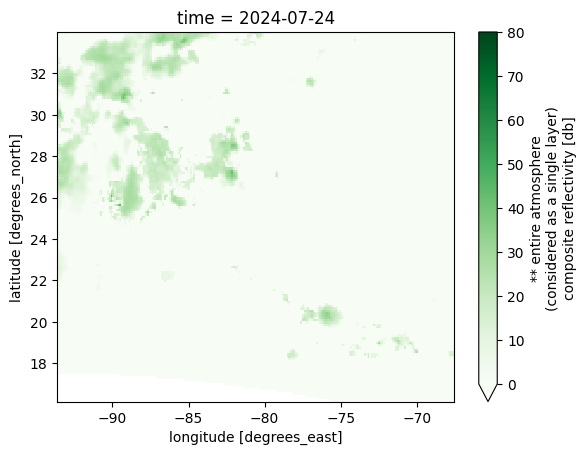
Create our region of interest and subset

bbox = [-93.63283364104035, 16.18222316056857, -67.60864242620244, 34.02542167172069]

ds_refd_subset = ds_refd.xsg.subset_bbox(bbox)
ds_refd_subset
<xarray.Dataset> Size: 5MB
Dimensions:  (lat: 161, lon: 230, time: 37)
Coordinates:
  * lat      (lat) float64 1kB 16.21 16.32 16.43 16.54 ... 33.72 33.83 33.94
  * lon      (lon) float64 2kB -93.58 -93.47 -93.35 ... -67.84 -67.73 -67.61
  * time     (time) datetime64[ns] 296B 2024-07-24 ... 2024-07-25T12:00:00
Data variables:
    refcclm  (time, lat, lon) float32 5MB dask.array<chunksize=(37, 161, 230), meta=np.ndarray>
Attributes:
    title:        NAM hourly fcst staring from 00Z24jul2024, download Jul 24 ...
    Conventions:  COARDS\nGrADS
    dataType:     Grid
    history:      Wed Jul 24 02:49:03 UTC 2024 : imported by GrADS Data Serve...
xarray.Dataset
- lat: 161
- lon: 230
- time: 37
- lat(lat)float6416.21 16.32 16.43 ... 33.83 33.94
- grads_dim :
- y
- grads_mapping :
- linear
- grads_size :
- 443
- units :
- degrees_north
- long_name :
- latitude
- minimum :
- 12.219908
- maximum :
- 61.20556254545
- resolution :
- 0.110827275
array([16.20969 , 16.320517, 16.431344, 16.542172, 16.652999, 16.763826, 16.874653, 16.985481, 17.096308, 17.207135, 17.317963, 17.42879 , 17.539617, 17.650444, 17.761272, 17.872099, 17.982926, 18.093753, 18.204581, 18.315408, 18.426235, 18.537063, 18.64789 , 18.758717, 18.869544, 18.980372, 19.091199, 19.202026, 19.312853, 19.423681, 19.534508, 19.645335, 19.756163, 19.86699 , 19.977817, 20.088644, 20.199472, 20.310299, 20.421126, 20.531953, 20.642781, 20.753608, 20.864435, 20.975263, 21.08609 , 21.196917, 21.307744, 21.418572, 21.529399, 21.640226, 21.751053, 21.861881, 21.972708, 22.083535, 22.194363, 22.30519 , 22.416017, 22.526844, 22.637672, 22.748499, 22.859326, 22.970153, 23.080981, 23.191808, 23.302635, 23.413463, 23.52429 , 23.635117, 23.745944, 23.856772, 23.967599, 24.078426, 24.189253, 24.300081, 24.410908, 24.521735, 24.632563, 24.74339 , 24.854217, 24.965044, 25.075872, 25.186699, 25.297526, 25.408353, 25.519181, 25.630008, 25.740835, 25.851663, 25.96249 , 26.073317, 26.184144, 26.294972, 26.405799, 26.516626, 26.627453, 26.738281, 26.849108, 26.959935, 27.070763, 27.18159 , 27.292417, 27.403244, 27.514072, 27.624899, 27.735726, 27.846553, 27.957381, 28.068208, 28.179035, 28.289863, 28.40069 , 28.511517, 28.622344, 28.733172, 28.843999, 28.954826, 29.065653, 29.176481, 29.287308, 29.398135, 29.508963, 29.61979 , 29.730617, 29.841444, 29.952272, 30.063099, 30.173926, 30.284753, 30.395581, 30.506408, 30.617235, 30.728063, 30.83889 , 30.949717, 31.060544, 31.171372, 31.282199, 31.393026, 31.503853, 31.614681, 31.725508, 31.836335, 31.947163, 32.05799 , 32.168817, 32.279644, 32.390472, 32.501299, 32.612126, 32.722953, 32.833781, 32.944608, 33.055435, 33.166263, 33.27709 , 33.387917, 33.498744, 33.609572, 33.720399, 33.831226, 33.942053]) - lon(lon)float64-93.58 -93.47 ... -67.73 -67.61
- grads_dim :
- x
- grads_mapping :
- linear
- grads_size :
- 913
- units :
- degrees_east
- long_name :
- longitude
- minimum :
- -152.878623
- maximum :
- -49.47263081081
- resolution :
- 0.11338376
array([-93.578915, -93.465531, -93.352147, ..., -67.8408 , -67.727417, -67.614033]) - time(time)datetime64[ns]2024-07-24 ... 2024-07-25T12:00:00
- grads_dim :
- t
- grads_mapping :
- linear
- grads_size :
- 37
- grads_min :
- 00z24jul2024
- grads_step :
- 1hr
- long_name :
- time
- minimum :
- 00z24jul2024
- maximum :
- 12z25jul2024
- resolution :
- 0.041666668
array(['2024-07-24T00:00:00.000000000', '2024-07-24T01:00:00.000000000',
       '2024-07-24T02:00:00.000000000', '2024-07-24T03:00:00.000000000',
       '2024-07-24T04:00:00.000000000', '2024-07-24T05:00:00.000000000',
       '2024-07-24T06:00:00.000000000', '2024-07-24T07:00:00.000000000',
       '2024-07-24T08:00:00.000000000', '2024-07-24T09:00:00.000000000',
       '2024-07-24T10:00:00.000000000', '2024-07-24T11:00:00.000000000',
       '2024-07-24T12:00:00.000000000', '2024-07-24T13:00:00.000000000',
       '2024-07-24T14:00:00.000000000', '2024-07-24T15:00:00.000000000',
       '2024-07-24T16:00:00.000000000', '2024-07-24T17:00:00.000000000',
       '2024-07-24T18:00:00.000000000', '2024-07-24T19:00:00.000000000',
       '2024-07-24T20:00:00.000000000', '2024-07-24T21:00:00.000000000',
       '2024-07-24T22:00:00.000000000', '2024-07-24T23:00:00.000000000',
       '2024-07-25T00:00:00.000000000', '2024-07-25T01:00:00.000000000',
       '2024-07-25T02:00:00.000000000', '2024-07-25T03:00:00.000000000',
       '2024-07-25T04:00:00.000000000', '2024-07-25T05:00:00.000000000',
       '2024-07-25T06:00:00.000000000', '2024-07-25T07:00:00.000000000',
       '2024-07-25T08:00:00.000000000', '2024-07-25T09:00:00.000000000',
       '2024-07-25T10:00:00.000000000', '2024-07-25T11:00:00.000000000',
       '2024-07-25T12:00:00.000000000'], dtype='datetime64[ns]')
- refcclm(time, lat, lon)float32dask.array<chunksize=(37, 161, 230), meta=np.ndarray>
- long_name :
- ** entire atmosphere (considered as a single layer) composite reflectivity [db]
Array Chunk Bytes 5.23 MiB 5.23 MiB Shape (37, 161, 230) (37, 161, 230) Dask graph 1 chunks in 3 graph layers Data type float32 numpy.ndarray
- timePandasIndex
PandasIndex(DatetimeIndex(['2024-07-24 00:00:00', '2024-07-24 01:00:00', '2024-07-24 02:00:00', '2024-07-24 03:00:00', '2024-07-24 04:00:00', '2024-07-24 05:00:00', '2024-07-24 06:00:00', '2024-07-24 07:00:00', '2024-07-24 08:00:00', '2024-07-24 09:00:00', '2024-07-24 10:00:00', '2024-07-24 11:00:00', '2024-07-24 12:00:00', '2024-07-24 13:00:00', '2024-07-24 14:00:00', '2024-07-24 15:00:00', '2024-07-24 16:00:00', '2024-07-24 17:00:00', '2024-07-24 18:00:00', '2024-07-24 19:00:00', '2024-07-24 20:00:00', '2024-07-24 21:00:00', '2024-07-24 22:00:00', '2024-07-24 23:00:00', '2024-07-25 00:00:00', '2024-07-25 01:00:00', '2024-07-25 02:00:00', '2024-07-25 03:00:00', '2024-07-25 04:00:00', '2024-07-25 05:00:00', '2024-07-25 06:00:00', '2024-07-25 07:00:00', '2024-07-25 08:00:00', '2024-07-25 09:00:00', '2024-07-25 10:00:00', '2024-07-25 11:00:00', '2024-07-25 12:00:00'], dtype='datetime64[ns]', name='time', freq=None)) - latPandasIndex
PandasIndex(Index([16.20968981818, 16.32051709091, 16.43134436364, 16.54217163636, 16.65299890909, 16.76382618182, 16.87465345455, 16.98548072727, 17.096308, 17.20713527273, ... 32.944608, 33.05543527273, 33.16626254545, 33.27708981818, 33.38791709091, 33.49874436364, 33.60957163636, 33.72039890909, 33.83122618182, 33.94205345455], dtype='float64', name='lat', length=161)) - lonPandasIndex
PandasIndex(Index([-93.57891475993, -93.46553099656,  -93.3521472332, -93.23876346983,
       -93.12537970647,  -93.0119959431, -92.89861217974, -92.78522841637,
       -92.67184465301, -92.55846088964,
       ...
       -68.63448681956, -68.52110305619, -68.40771929283, -68.29433552946,
       -68.18095176609, -68.06756800273, -67.95418423936,   -67.840800476,
       -67.72741671263, -67.61403294927],
      dtype='float64', name='lon', length=230))
- title :
- NAM hourly fcst staring from 00Z24jul2024, download Jul 24 02:41 UTC
- Conventions :
- COARDS GrADS
- dataType :
- Grid
- history :
- Wed Jul 24 02:49:03 UTC 2024 : imported by GrADS Data Server 2.0
Plot the first timestep
ds_refd_subset.cf.isel(time=0).refcclm.plot(vmin=0, vmax=80, cmap="Greens")
<matplotlib.collections.QuadMesh at 0x311d7a350>
f"Subset dataset size: {ds_refd_subset.nbytes * 1.0e-6} Mb"
'Subset dataset size: 5.483864 Mb'